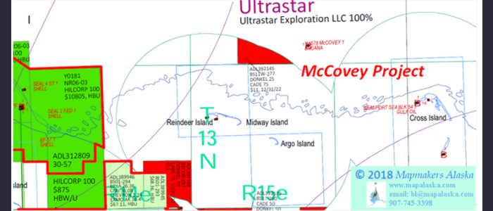
McCovey
McCovey Project
McCovey
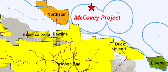
Off-shore, North Slope
- Key Features
- Project lies 6 miles east of the Northstar Unit (196 MMBO), 6 miles northeast of the Prudhoe Bay Unit (15.2 BBO), and 11 miles northwest of the Duck Island Unit (585 MMBO).
-
- Seal Is. OCS-181-1 Well: tested 4,903 BOPD (40 API) in the Sadlerochit Group.
- Reindeer Is. Strat #1 Well: encountered porous Sadlerochit Conglomerate.
- No Name Island #1 Well: had oils shows in the Kingak, Sag River, and Ivishak (Sadlerochit Grp.). DST in the Ivishak flowed 1,263 BWPD.
- Beaufort Sea #54-1/1A Wells: encountered numerous oil shows in a 4,541’ section above basement.
- McCovey #1 Well: encountered excellent quality reservoir sands in the Tertiary Brookian sequence.
- Leases
- ADL 392145 (12/31/2022)
D.T. Gross 1/30/18
The Donkel/Cade McCovey Project is comprised of a single lease of 967 acres located approximately 11 miles north of the Beaufort Sea shoreline. The project area lies 2 miles north-northeast of Reindeer Island (Midway Islands) in State of Alaska waters with depths between 12 and 15 feet. Numerous fields are located near the Donkel/Cade leasehold with the project being only 6 miles east of the Northstar Unit, 6 miles northeast of the Prudhoe Bay Unit, and 11 miles northwest of the Duck Island Unit (Endicott Field). Additionally, the McCovey Project is 3 miles east-southeast along trend from the extensive 64-lease position held until recently by Shell, ENI, and Repsol.
Prudhoe Bay Field’s cumulative production is 12.2 billion barrels of oil from strata ranging in age from Carboniferous to Cretaceous. The Endicott Field (Duck Island Unit) has produced 471 million barrels of oil primarily from the Mississippian Kekiktik Conglomerate with a contribution from the Lower Triassic Ivishak Formation. The Northstar Field’s cumulative production is 153 MMBO from the Triassic Sag River, Shublik, and Ivishak formations. The lithology at Northstar is comprised of delta-front sandstones and shales of the Ivishak that transition upwards into the shelf deposits of the Shublik and Sag River. The trap is an anticline that is bounded by a fault to the north and which displays structural closure to the east, south, and west.
The McCovey Project and surrounding area have seen surprisingly little exploration drilling, considering its proximity to world class oil fields. Aside from the 1969 Reindeer Island #C1 corehole that reached a depth of just 509’, the first significant well drilled near the project acreage was Sohio’s 1979 Reindeer Island Stratigraphic Test #1. Located on the western portion of Reindeer Island and less than 3 miles southwest of the project area, the well reached a depth of 14,352’ MD (13,645’ TVD) along a path deviated ¾ of a mile to the south-southwest. This industry consortium well was deliberately positioned off structure in order to minimize the likelihood of encountering hydrocarbons. The well bottomed in the basement Precambrian schist and thus the entire prospective stratigraphic section of the area from Tertiary through Carboniferous was thoroughly sampled and evaluated, with 294 sidewall cores shot and 15 conventional cores cut. Overall, the sidewall cores showed the Cretaceous sandstones to be very fine to medium grained and friable. The conventional cores revealed that the Lower Triassic Sadlerochit and deeper clastics ranged from shale to conglomerates, having visible porosities from “none seen” to very good. Despite having been designed to avoid hydrocarbons, the well did record 7 hydrocarbon shows; 2 gas shows in the Mississippian Kayak Formation above basement (14,008-24’MD; 13,975-80’MD), an oil show in the L. Triassic Sadlerochit (Ivishak) that had dead oil in fractures and oil bleeding from sandstone laminae (12,091-106’MD), and 4 oil shows in the Upper Cretaceous with yellow-white fluorescence, streaming cuts, and brown oil stains (10,561-687’MD; 10,440-561’MD; 10,230-440’MD; 9,210-50’MD). Additionally, conventional cores showed the Carboniferous Lisburne limestones to be extensively fractured with most horizontal and vertical fractures being open. The Mississippian Kekiktuk Formation was not identified in the well, but Core #14 taken in the Mississippian Kayak Formation (13,876-89’ MD) did contain nine feet of “quartzite with silica overgrowths” (orthoquartzite) in its basal section and the mudlog showed that “quartzite” was interbedded with mudstone for the next 50’.
The next nearest wells were both drilled by the Gulf Oil Corporation during the winter season of 1983-84 at Cross Island, 5 ½ miles southeast of the McCovey Project. The Beaufort Sea #54-1 and the Beaufort Sea #54-1A sidetrack were designed to evaluate the known Mesozoic productive interval of the area as well as the pre-Mississippian section above economic basement. The Beaufort Sea #54-1 was drilled to a depth of 14,538’ MD (14,244’ TVD) and penetrated the basement Devonian(?) argillite at 14,012’ MD. The well encountered the Jurassic Kingak Formation at 12,440’ MD, the Triassic Sag River at 13,906’ MD, and the Shublik at 13,953’ MD. (The Ivishak, Lisburne, and Kekiktuk formations were missing). One conventional core was taken in the basement argillite (14,510’-14,538’ MD) which had neither hydrocarbon shows nor porosity. Sidewall cores were taken throughout the interval from 9,465’ to 14,500’ MD. They showed the section above basement to be a mixture of sandstones, siltstones, and shales that displayed numerous shows of yellow fluorescence, streaming cuts, and even possible dead oil. The well was plugged back to 12,550’ and the sidetrack 54-1A was drilled with a bottomhole location approximately 640’ to the northeast at a depth of 14,534’ MD (14,240’ TVD). No sidewall cores were taken in #54-1A and the only log run was a GR/TDT/CCL run inside casing due to hole problems. The well was plugged and abandoned due to the lack of economic hydrocarbons.
Four miles due south of the #54-1 and #54-1A wells, Amoco Production Company (BPAP) had earlier drilled the No Name Island #1 well in April, 1982 to a depth of 14,350’ MD (11,345’ TVD). The well encountered the “Base Delta” at 9,375’ (7,486’ TVD), the “Prudhoe Bay Unconformity” at 13,200’ (10,411’ TVD), the Sag River Sandstone at 13,620’ (10,748’ TVD), the Shublik at 13,695’ (10,810’ TVD), the Ivishak at 13,800’ (10,896’ TVD), and the basement argillite at 14,200’ (11,226’ TVD). Three conventional cores were taken during drilling. The first appears to have been taken in the Jurassic Kingak Formation (12,924’-12,953’ MD) and revealed thin shale and fine sand cycles which displayed gold fluorescence. A core in the Triassic Lower Sag River / Upper Shublik (13,667’-13,726’ MD) was comprised of very fine to fine grained sandstones with oil staining, good cuts, and fluorescence. One horizon had an erosive base overlain with rip-up conglomerates. The deepest core, cut in the Ivishak Formation (13,866’-13,896’ MD), was composed entirely of fine to medium grained sandstone with oil staining. A drillstem test taken over this interval (Test #1, 13,849’-13,979’ MD) revealed very good permeability with a flow rate of 1,263 BWPD. The second test (DST #2, 13,644’-13,673’ MD) in the Sag River returned 28 barrels of gas and mud cut water with a film of oil. DST #3 (12,880’-12,910’) was taken above the “Prudhoe Bay Unconformity” in the Kingak(?) and flowed gas at a rate of 60 MCFGPD. Though the well was plugged and abandoned due to the lack of economic hydrocarbons, the State of Alaska agreed to Amoco’s request to extend the confidentiality of its data beyond the normal 24 months until 30 days after the Federal OCS Sale 87 (held on October 1, 1984).
For more than a decade and a half after this spate of drilling, the area around the McCovey Project saw leasing activity but no exploration drilling until the McCovey #1 well in November, 2002. The preliminary results map for the October 24, 2002 Beaufort Sea Areawide Lease Sale showed that nearly every block was leased in the area of Cross Island and the Midway Islands (Reindeer Is./Argo Is.), as were the Federal OCS blocks that surrounded them. The original “McCovey Prospect” included 4 Federal OCS leases and 14 Alaska State leases, but these were trimmed down to 3 OCS leases (8,133 acres) and 4 state leases (20,371 acres) when the McCovey Unit was approved in September of 2000. The original unit partners ChevronTexaco and ConocoPhillips cancelled their plans in May of 2001 to drill a well on a spray-ice island on their OCS-Y-1577 lease due to changes in the State of Alaska’s drilling policy. In October of 2001, Encana (Alberta Energy Company) was brought in as a 30% share partner and assumed operatorship of the McCovey #1 well, which had its surface location moved west to the OCS-Y-1578 lease block and would now utilize a steel drilling caisson (SDC) set on the seafloor in 35’ of water. This new location is less than 1 mile north of the Donkel/Cade McCovey Project acreage. The McCovey #1 was planned to test basal Tertiary Brookian targets above 13,000’ that were identified using newly acquired high quality seismic data. Prior to spudding the well, the unit partners snapped up the 8 state leases (19,840 acres) that were available on the unit’s south and east sides, effectively tying up the last of the acreage surrounding the McCovey Unit. There was much expectation by industry and the State of Alaska that the well would lead to a major discovery of oil reserves that would give a much needed boost to North Slope production. Unfortunately this was not the case, though the well did encounter excellent quality reservoir sands in the objective section. The McCovey #1 well was plugged and abandoned on February 9, 2003. Some have theorized that the well was drilled too far structurally downdip to the north and that the oil was trapped further to the south, closer to the paleo-shelf edge. Though the McCovey #2 well was widely expected to be officially proposed, it never was and the unit was dissolved in June of 2003 and the leases relinquished as their primary term had expired in July, 2001. The area around the present day McCovey Project continued to be considered prospective by other companies such as Pioneer Natural Resources which held 7 leases over this area, but they relinquished them in 2009 along with 44 other leases located south of the Prudhoe Bay Unit as part of a shift in Pioneer’s focus away from regional exploration activity and towards development of its Oooguruk Field.
The McCovey Project sits in the desirable position of being immediately updip of excellent Tertiary Brookian sands in a hydrocarbon rich area. Why only one well was drilled to evaluate this exploration play that includes the large Shell/ENI/Repsol leasehold to the northwest and the entire McCovey Unit (expired) must be attributed to “timing” and the changing financial objectives of the major oil companies involved. In short, the well that should have been a “no-brainer” follow-up to the McCovey #1 still remains to be drilled a decade and a half later, leaving the McCovey Project acreage essentially untested. Also remaining to be evaluated is the section below the Tertiary. Though the sub-Shublik Formation strata in the Beaufort Sea #54-1 and #54-1A wells were missing, this may have been due to erosion or faulting and there still exists potential at McCovey. An even more likely additional target horizon would be the Upper Triassic Sag River Sandstone which had oil shows in these wells, just as it did in the No Name Island #1 well to the south.