West Northstar
West Northstar
 Off-shore, North Slope
- Key Features
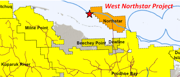
- Project is adjacent to the Northstar Unit (196 MMBO), 6 miles north of the Beechey Point Unit (~100 MMBO), and 10 miles east of the Mine Point Unit (529 MMBO).
- Project lies 4 miles southeast of the Sandpiper Discovery (12-47-150 MMBO).
- Long Island #1 Well: oil shows in L. Cretaceous Kuparuk cores (22-27 API); oil shows in Triassic Sag River sand and Ivishak Formation.
- North Star #1 Well: 3 zones in the Ivishak tested 1,920/2,000/3,100 BOPD (41-52 API). Kuparuk test: 3% oil (30 API).
- Leases
- ADL 392152 (12/31/2022)
Geologic Summary by: D. T. Gross (2/3/2018)
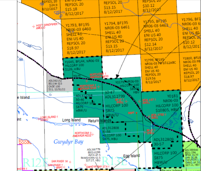
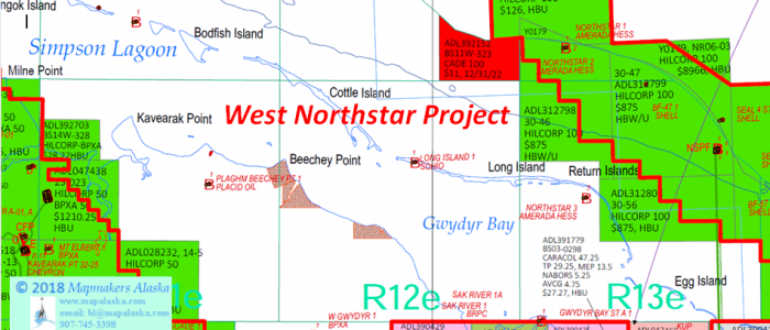
The West Northstar Project is comprised a single lease of approximately 1,480 acres, located 5 miles offshore from Beechey Point in State of Alaska waters with depths between 10’ and 12’. However, the project lies only 2 miles northeast of Cottle Island and 2 miles north of Long Island. The project sits amidst established oilfields and discoveries. The Northstar Unit (196 MMBO) is immediately adjacent to the east, the Beechey Point Unit (~100 MMBO) is 6 miles to the south, the Milne Point Unit (529 MMBO) is 10 miles to the west, and the Sandpiper Discovery (12-47-150 MMBO) is 4 miles to the northwest. Additionally, the West Northstar Project is less than 2 miles south of an extensive 64-lease position once held by Shell, ENI, and Repsol. Their leasehold encompassed the Federal OCS acreage that was closest to the northern borders of the oil and gas units in the Colville River-Kuparuk-Prudhoe Bay area. Also, Devon Energy held five Alaska State leases adjacent to the project acreage to the northwest, immediately southwest of the Sandpiper Discovery, but allowed them to expire on 6/30/12 without drilling any wells.
The Northstar Unit is a joint State of Alaska and Federal unit that was formed in 1990 (Federal approval) based upon Triassic oil pays that were encountered in Shell’s 1984 discovery well (BF- 47 #1; ~ 5,000 BOPD) and a confirmation well (OCS-181 Seal Island #1; 4,903 BOPD; 39.5 degree API oil; 12.8 MMCFGPD). Four additional confirmation and delineation wells were drilled through 1986. To date, the unit has produced 166 MMBO from the Triassic “Northstar Pool” with only a 3.7 MMBO contribution from three L. Cretaceous Kuparuk Formation completions. The Triassic Ivishak is a superior reservoir with its 325’ of delta front sands (105’ net pay) that average 15% porosity with 53 md permeability (Swi 54%). The 44 degree API oil has a column of 270-300’ and is trapped on the south side of a faulted anticline that has dip closure to the west, south, and east. With maximum throws of 200’, most faults within the field itself are not thought to interfere with communication between the fault blocks and a common oil/water contact is placed at 11,100’ SS. The Kuparuk reservoir sandstones are divided into two intervals, the C-Sands and the underlying A-Sands. The C-Sands interval thins over the crest of the anticline and thickens downthrown to faults, indicating that structural folding was followed by syndepositional fault activity. The A-Sands consist of three to five upward-coarsening intervals which do not appear to have been influenced by faulting or the fold structure during deposition. The trapping mechanism for the Kuparuk sands, as for the Ivishak, is a combination of structural dip and several southeast and north-trending, normal faults. This fault-control of oil accumulation is especially important in that the West Northstar Project lies downdip and along structural trend to the west, but is in a distinctly separate fault block as shown on an AOGCC Northstar Unit structure map. The most recent developments at Northstar began in 2012 when BP applied for a new Participating Area for the further development of the Kuparuk sands. The State approved the Hooligan PA in 2015, retroactive to 2006, and just recently in 2018 approved a new pool (NSKOP) for the Kuparuk reservoirs. The new pool designation allowed for the comingling of production from the C-sands with that of the A-sands. Though technically an oil pool, the recoverable reserves for the Kuparuk at the Northstar Unit are predominately gas, 220 BCFG and 10 MMBO.
Of particular relevance to the West Northstar Project is the Northstar #1 well, drilled by Amerada Hess in 1986 as one of the Northstar delineation wells. Located just 1 mile east of the project acreage, the Northstar #1 (11,820’ MD(TVD)) tested three zones in the Ivishak that flowed at rates of 1,920 BOPD, 2,000 BOPD, and 3,100 BOPD (41-52 degree API). A test uphole in the Kuparuk determined that it contained some oil (3% oil; 30 degree API). Amerada Hess returned to the western portion of the Northstar Unit eight years later when it drilled the Northstar #3 well (10,000’ MD; 9,562’ TVD) in a location 3 1/2 miles southeast of the project acreage. Surprisingly, the well was only drilled down to a Kuparuk target which was determined through conventional and sidewall core analyses to be marginally gas productive. Despite oil saturations that averaged 4.8% in “Zone 4” at 9,561-93” MD, the Northstar #3 was plugged and abandoned, as was the previously suspended Northstar #1 well.
The Beechey Point Unit, 6 miles south of the West Northstar Project, was formed in 2009 with Brooks Range Petroleum Corporation (BRPC) as its operator. At one time it contained 30 leases covering 52,879 acres that contained oil accumulations peripheral to the northern edge of the Prudhoe Bay Unit. According to the Alaska Division of Oil and Gas, the Beechey Point Unit “lies north of the northwest to southeast trending, down-to-the-north, Prudhoe fault that separates the Prudhoe Bay field from deeper, more complexly faulted structures to the north”. The primary exploration targets at Beechey Point are sandstones in the L. Triassic Ivishak Formation and the U. Triassic Sag River Formation, as well as the L. Cretaceous Kuparuk Formation. The unit was divided into five Exploration Blocks, each of which was required to have been tested by an exploration well by 2019, (North Shore EB, West Shore EB, Northwest Shore EB, East Shore EB, and Offshore EB). Undeveloped oil discoveries in the area date back to the 1969 Hamilton Brothers Storkersen #1 well (future Dewline Unit). However, the Beechey Point Unit approval was based upon the 2007 BRPC North Shore #1 well being sidetracked in 2008 and encountering 70’ of oil in the Ivishak. A DST that flowed at a rate of 2,092 BOPD led to the well being certified as Capable of Producing in Paying Quantities (CPPQ). In 2010, BRPC drilled wells within two of the Exploration Blocks and suspended both. In the North Shore EB, the North Shore #3 well (11,414’ MD; 10,601’ TVD) was drilled into a Sag River – Ivishak target that displayed 4-way closure and was reported to have 11 MMBO in reserves. Two miles to the northeast in the Offshore EB, the Sak River #1A well (12,716’ MD; 9,396’ TVD) proved up 4.5 MMBO in reserves in the Kuparuk. Presently the plan for the North Shore Development Project is to produce oil from several relatively small, isolated hydrocarbon accumulations within the 15,000-foot horizontal drilling radius of their drilling pad. The Ivishak and Sag River sands will be produced from each prospect using horizontal drilling technology and long-reach wells to recover between 5 and 10 million barrels of oil, (22% porosity, 39 degree API). In total, these prospects are expected to contain approximately 100 MMBO in reserves. Recent news suggests that there may be efforts to move forward on these drilling plans in the near future. In July of 2017, the DNR approved a transfer of small (3-5%) working and royalty interests to Nabors Drilling Technologies USA Inc. from Ramshorn Investments Inc., the unit’s largest W.I. partner. It is noteworthy that Ramshorn Investments is a subsidiary of Nabors Industries, Ltd.
The Milne Point Unit was formed in 1979 based primarily on the discovery well drilled by Standard Oil of California (SoCal) in 1969. The Kavearak Point #1 was drilled to 9,799’ MD(TVD) with targets in the L. Cretaceous Kuparuk Formation, the U. Triassic Sag River Sand, and the L. Triassic Ivishak Formation. The Paleozoic carbonates of the Lisburne Group were not reached. The well cut 13 conventional cores, shot numerous sidewall cores, and ran several DST’s which indicated the presence of hydrocarbons in all three of the exploration targets as well as in the Upper Cretaceous Schrader Bluff Formation. Both the Sag River Sand and the Ivishak were found to have low permeability and the latter was determined to be salt water productive with some oil and gas. Tests in the Kuparuk Formation flowed at rates of 970-1,340 barrels per day of 23.6 degree API oil. The Milne Point Unit was delineated and developed by ARCO beginning in 1980 and the first production was in 1985. In 1994, BP became the unit operator and greatly expanded the field development. To date, the unit has had a cumulative production of over 342 MMBO primarily from the Kuparuk and Schrader Bluff Formations, 259 MMBO and 80 MMBO respectively. Despite being labeled as “tight” in the discovery well, the Sag River Sand has contributed 3.2 MMBO to the cumulative unit production. The Kuparuk was deposited upon a marine shelf and is divided into four units, the “A” and “C” being most productive. The reservoirs are thin sands with net pay of 5-60’, 23% porosity, 20-40 md, 21-26 degree API, and 33% Swi. The Schrader Bluff was deposited as shallow marine distal deltaic sands on a muddy shelf. It is subdivided into the “O Sands” and the “N Sands” with net pay of 10-50’, 28% porosity, 171 md, 14-22 degree API, and 40% Swi. The trapping mechanism at Milne Point is down-to-the-northeast normal faulting that is crosscut by NE-SW trending faults that act as productive seals between adjacent fault blocks and result in different oil/water contacts. The regional dip in the area is 1 to 2 degrees to the northeast and the official description of the Kuparuk reservoir is that of a faulted anticline with production confined to the crest and northeast flank. However, the AOGCC’s Top Kuparuk River Formation structure map displays little to no structural development of the “southwest flank” of this anticline and the trapping mechanism appears to be almost entirely reliant upon the dominant NW-SE trending faults interrupting the gentle northeast regional dip of the strata. Hilcorp Alaska, the new unit operator, has been focused on field development drilling and well workovers to increase production, most recently at their Moose Pad on the western side of the unit. In 2016, Hilcorp did apply and was approved to expand the Milne Unit by 1,268 acres on its eastern edge, 9 miles south-southwest from the West Northstar Project.
The now-dissolved Sandpiper Unit was located a mile to the north of the West Northstar Project in Federal OCS waters of the Beaufort Sea. The unit was formed over a L. Triassic Ivishak Formation oil discovery that was found by two wells drilled by Shell and AMOCO in 1986 from surface locations on an artificial island constructed in 49’ of water. The Sandpiper #1 well was drilled to 12,575’ MD and tested two zones below 11,910’ MD in the Sadlerochit Group (Ivishak Fm.) that flowed from 500 to 2,500 BOPD (40-52 degree API) and 18.5 MMCFGPD. Sandpiper #2 also encountered the oil pay and both wells were certified as being Capable of Producing in Paying Quantities, leading to the formation of the Sandpiper Unit in 1992. The OOIP was reported to be 450 MMBO and values for the recoverable reserves have ranged between 47-150 MMBO, though later assessments have been lower. The unit operatorship transferred from BP to Murphy Oil in 1999 and the predicted field production rate was changed from 12,000 BOPD down to 8,000 BOPD with expectations for the oil to be processed at the Northstar Unit facilities. Three delineation wells were planned for the 2000 drilling season but were never spudded. It is not certain why, but it appears that the combined effects of oil prices in the mid $20’s, the necessity of constructing an island pad north of the barrier islands, and the expectation that the Northstar Unit would be capacity-constrained until 2005 led to the abandonment of the Sandpiper Unit and the relinquishment of its leases upon their expiration in April, 2001. However, Sandpiper was determined to be a “significant discovery” by the ADOG in 2000 and by the MMS in 2001. In 2003 at the first lease sale in the area since 1998, ConocoPhillips acquired three tracts over the Sandpiper discovery. In 2009, ConocoPhillips retained these three federal leases even as the company was in the process of dropping over 100,000 acres of leases as part of the shift of their exploration focus to the Chukchi Sea. At the time, the 15,000 acres of the Sandpiper prospect were estimated to hold between 20 million and 70 million barrels of oil. Though they spent $4 million on the lease bonus bids, ConocoPhillips did not do any drilling at Sandpiper and today the acreage remains unleased, despite being surrounded until recently by the extensive Shell/ENI/Repsol lease position to the north and the Devon leases to the south. This situation may be related to a 2009 DOE North Slope report that stated that the development of the Sandpiper discovery would be dependent upon the development of discoveries nearer to shore at Gwyder Bay and areas north of the Kuparuk Field. It predicted that it would be 2015, at a minimum, before development would begin at Sandpiper with the construction of a production/drilling pad north of the barrier islands, (a location 3 miles west of the West Northstar Project).
Aside from those wells previously discussed, there is a key well significant to the West Northstar Project. Two miles south-southwest of the project acreage, the Sohio Long Island #1 well was drilled in 1984 to a depth of 11,600’ MD(TVD) from an icepad constructed on the western end of Long Island. Though unsuccessful in finding economic hydrocarbons, the well did have numerous oil shows in the L. Cretaceous Kuparuk Formation (8,980’ MD; 8,939’ TVD), the U. Triassic Sag River Sand (11,078’ MD; 11,037’ TVD), and the L. Triassic Ivishak Formation (11,265’ MD; 11,224’ TVD). Of the four conventional cores cut in the well, the two deeper cores in the Kuparuk had extensive oil shows. Core # 4 (9,158-218’ MD) showed the Kuparuk B to be composed of shales and very thin, fine-grained sandstones that had scattered brown staining, dull gold fluorescence, and milky cuts. Core #3 (9,042-102’ MD) was cut in a Kuparuk C sandstone that was fine-medium grained, had strong petroliferous odors, and displayed continuous brown oil staining, dull gold fluorescence , and strong milky cuts down to its base at 9,091’ MD. Though no conventional cores were cut in the deeper strata, the single sidewall core recovered from the Sag River Sand (11,120’ MD) was of very fine-grained sandstone with brown oil staining, yellow-gold fluorescence, and a milky cut. The SWC’s recovered from the Ivishak showed it to be composed of friable, fine to medium grained sandstones interbedded with claystones. A single SWC from the upper portion of the formation (11,277’ MD) displayed yellow-gold fluorescence and a milky cut.
In summary, the West Northstar Project sits amid major oil production and discoveries. An exploration well that was drilled just to the south of the project acreage displayed good oil shows and reservoir quality sands in the stratigraphic equivalents to these fields’ reservoirs. The L. Cretaceous Kuparuk Formation has production at the Milne Point Unit to the west (242 MMBO cum.), from three completions at the Northstar Unit to the east (3.7 MMBO cum.), and has reserves assigned to it in the Offshore Exploration Block of the Beechey Point Unit to the south (4.5 MMBO). The U. Triassic Sag River Sand is also productive at both the Milne Point and Northstar units, and is part of the reserves being assigned to the Northshore Development Project in the Beechey Point Unit. Though not productive to the west of the project acreage, the L. Triassic Ivishak has produced 166 MMBO at the Northstar Unit to the east, was assigned recoverable reserves of 47-150 MMBO at the Sandpiper Discovery to the north, and has had tens of millions of barrels of reserves assigned to it thus far at the Beechey Point Unit to the south. Additionally, oil reserves may be discovered at the West Northstar Project in Triassic Shublik sands that are similar to those that are part of the Northstar Pool production or in Tertiary Schrader Bluff sands like those that are productive at the Milne Point Unit (67 MMBO cum.).