


East Point Thomson (Stinson)
Stinson, East Point Thomson
Off-shore, Eastern North Slope
- Key Features
- Stinson #1 Well is within the project area: 3,500’ section of oil & gas shows; Base Eocene Unconf. Sand assigned 210 MMBO probable reserves; Base Tert. Unconf./Pre-Miss. test yielded 430 BOPD (37-51 API), 7-18 MMCFGPD, 520 BWPD (173 BWPD net) under poor hole conditions (700-800 BOPD cleanhole estimate).
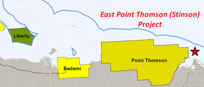
- Point Thomson Unit lies ½ mile to the west.
- ANWR: USGS study that assigned 10.3 BBO reserves to ANWR identified 6 distinct plays over the project area.
- External references:
- Water Depths ± 50’
- Leases
Geologic Summary by: D. T. Gross / D. Brizzolara (4/9/2012), updated by R. Morse (2/2018)
View a Detail Map
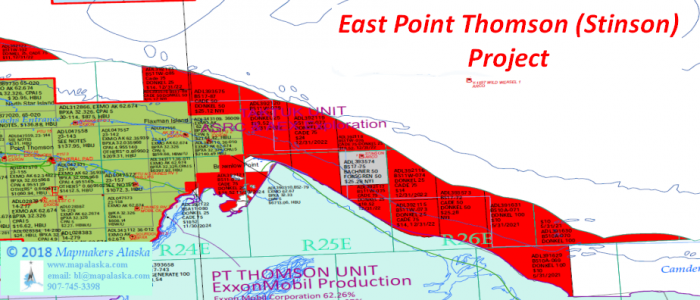
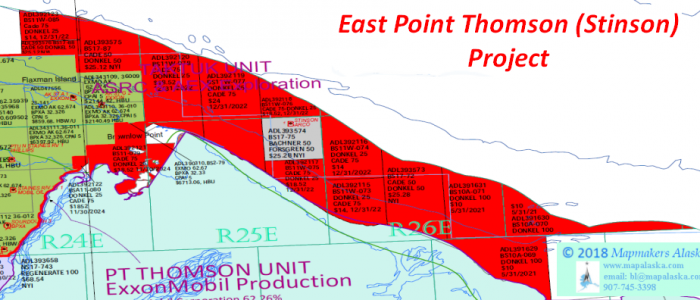
The Stinson, East Point Thomson Project is comprised of thirteen leases totaling approximately 68,000 acres: ~52,300 contiguous acres near the Stinson-1 well (not including the Stinson-1 lease block) and ~ 15,700 acres near the Alaska A-1 and Challenger-1 wells. This acreage is located in Alaska State Waters at depths of +/- 50’ and lies immediately north of the ANWR 1002 Area. The leasehold is centered over two oil and gas discoveries at the Stinson-1 well. This well proved producible oil from an Eocene SS, as well as oil and gas from a highly fractured and oil saturated Pre-Mississippian (probably Cambrian) sandstone.
This leasehold block lies along the southeasterly plunging nose of the Barrow Arch, at the Beaufort rift margin, and is 1⁄2 mile east of the Point Thomson Unit where Exxon made discoveries of both oil (Tertiary Flaxman Turbidites; 75 MMBO; 1975) and gas/condensate (Cretaceous Thomson sand; 300 MMBO, 9 TCFG; 1977). Two additional oil discoveries are located near the Stinson project acreage in the OCS Federal Waters of the Beaufort Sea; Kuvlum (265 MMBO) lies 9 miles to the northeast and Sivulliq (previously Hammerhead; 150 MMBO) lies 12 miles to the northwest. One well has been drilled within the Donkel/Cade leases and was the basis of assigning 150 MMBO of economic reserves to the project in 2010 (210 MMBO reserves total). The ARCO Stinson #1 well encountered a 3,500’ section of oil and gas shows that were confirmed by conventional and RSW cores, as well as an openhole drillstem test.
In 1990 the Stinson #1 well successfully proved up the potential of two play concepts unique to the North Slope. One is localized upon and within the structural nose of the fractured Franklinian basement (regionally Devonian(?) to Precambrian) where the sandstone and carbonate strata were tested in the open hole from 14,863’ to 15,194’ MD in the Cambrian (?). The DST #1 flowed oil and gas at rates of 430 BOPD (37 to 51 API gravity), 7.1 -18.0 MMCFPD, and 520 BWPD (2/3 of which was load water). It was predicted that flow rates would have reached 700 to 800 BOPD under clean-hole conditions had not the test been impeded by shale sloughed from up-hole. Furthermore, the highly fractured reservoir would have undoubtedly performed at significantly higher rates had it been targeted by an optimally oriented horizontal well, contacting far more productive fractures it than the original vertical wellbore. Resource in this discovered accumulation is likely in the 200-400 MMBO range, but is highly uncertain due principally to poor seismic data. A younger play occurs in the Lower Eocene sands that were deposited in shallow water shelf to deep-marine environments. A single 100’ sand that is situated directly above the Basal Eocene Unconformity (BEU) and utilizes a combined structural-stratigraphic trap was assigned 150 MMBO of probable economic reserves & 210 MMBO resource in an independent 2010 engineering study by PetroTechnical Resources Alaska, LLC (P90: 80 MMBO; P10: 420 MMBO). 3D seismic data is needed to clarify and focus the appraisal of both the Eocene and Pre-Mississippian discoveries.
Approximately 16 miles of pipeline would be required to connect the Stinson Project production to the planned 22 mile-long pipeline between the Point Thomson and Badami fields. An Initial Production System (IPS) timetable was laid out in the recent settlement agreement between the State of Alaska and ExxonMobil which will preserve the Point Thomson Unit. The pipeline connection to Badami (a common carrier with a 70,000 barrel per day capacity) clearly has spare ullage (perhaps >60,000 B/D) due to the Badami development failure, with its production facilities designed for 38,500 B/D but only producing at ~1,000 B/D. The PTU-15 and PTU-16 wells were drilled early in 2009 as part of ExxonMobil’s development project for the field.
The appraisal of reserves at Stinson require a quality 3D seismic survey, capable of informing drilling decisions for both the Eocene and Pre-Miss levels. A large enough survey will help identify features controlling the accumulation size, and could expose the operator to additional exploration prospects. This area is highly underexplored and the structural and stratigraphic complexities of this rift margin are not fully appreciated. New productive horizons are probable because recent seismic mapping has shown that it is possible to move more than 800’ structurally updip from the ARCO Stinson #1 well location and still be within the Donkel/Cade leasehold. This seismic data clearly shows reflectors indicating a prograding shelf edge of Eocene to Oligocene age with associated foreset and bottomset units which were not encountered by the Stinson #1 well. The oil pay zones in the Flaxman Island, Alaska State #A-1 (2,507 BOPD; 23 API oil) and Sourdough (100 MMBO) discoveries of the Point Thomson Unit are trapped in similar strata, as are the Hammerhead and Kuvlum discoveries in the OCS waters.
At Point Thomson where the API gravities range from 18 to 45 degrees, the Alaska State #F-1 well proved the basement reservoir play to be valid when it tested strata immediately below the LCU at 152 BOPD (35 API) with 3.0 MMCFGPD and the Alaska State #A-1 well displayed great basement permeability with a test that flowed 4,220 BWPD. This result is significant in that it proves sealed separation from the downdip Stinson oil and gas discovery, begging the question of appraising the updip extent of the Stinson hydrocarbon accumulation.
ANWR sits South and East of portions of this acreage block. There is emerging evidence that several plays may have significant potential in NW ANWR and that potential could be tested by drilling on lease ADL-392121. This includes the Flaxman, Pt Thomson, and Pre-Miss plays. A 1998 USGS report on the petroleum potential of the ANWR 1002 Area calculated that 10.3 BBO of reserves were contained in ten plays in this area and the adjacent State of Alaska Waters.
In summary, the East Point Thomson Project (aka the Stinson Discovery) has 210 MMBO probable reserves assigned to its Base Eocene Sand with potential Brookian oil accumulations both above and below it. It also has DST results that prove a Pre-Mississippian oil and gas accumulation with significant multi-hundred MMBOE potential. Both discoveries need high quality 3D seismic to support their appraisal. Furthermore, both the complex rifted Beaufort margin as well as NW ANWRs Barrow Arch frontier are likely to yield significant economic discoveries. Exploration, appraisal, and development in both settings will be far more efficient with game-changing drilling and completion technologies not in place during the previous cycles of exploration in these areas.
