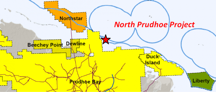
North Prudhoe
North Prudhoe Project
North Prudhoe
Off-shore, North Slope
- Key Features
- Project lies along north border of the Prudhoe Bay Unit (15.2 BBO), 2 miles east of the Northstar Unit (196 MMBO), 6 miles northwest of the Duck Island Unit (585 MMBO).
-
- Seal Is. OCS-181-1 Well: tested 4,903 BOPD (40 API) in the Sadlerochit Group.
- Reindeer Is. Strat #1 Well: encountered porous Sadlerochit Conglomerate.
- No Name Island #1 Well: had oils shows in the Kingak, Sag River, and Ivishak (Sadlerochit Grp.). DST in the Ivishak flowed 1,263 BWPD.
- Gull Island State #1: tested 1,144 BOPD (22 API) from the lower Shublik Fm. (Pebbly Sandstone equivalent(?)). DST in the Sadlerochit flowed 1,190 BOWD.
- Gull Island State #2: tested 2,971 BOPD from the Lisburne Formation.
Geologic Summary by: D. T. Gross (1/29/2018)
The Donkel/Cade North Prudhoe Project is comprised of two leases and one tract, totaling approximately 4,280 acres, located between 3 and 7 miles north of the Beaufort Sea shoreline. The project area lies northeast of Stump Island (Return Islands) in State of Alaska waters with depths between 5 and 25 feet. Numerous fields are located near the Donkel/Cade leasehold with the project area being adjacent to the northern boundary of the Prudhoe Bay Unit, 2 miles east of the Northstar Unit, 6 miles northwest of the Duck Island Unit (Endicott Field), and 5 miles east of the Dewline Unit.
The Prudhoe Bay Unit’s cumulative production is 12.7 billion barrels of oil from strata ranging in age from Carboniferous to Tertiary. The Duck Island Unit (Endicott Field) has produced 486 million barrels of oil primarily from the Mississippian Kekiktuk Conglomerate with a contribution from the Lower Triassic Ivishak Formation. The Northstar Unit’s cumulative production is 169 million barrels of oil from the Triassic Sag River, Shublik, and Ivishak Formations. The lithology of Northstar’s stratigraphic section is comprised of delta-front sandstones and shales of the Ivishak that transition upwards into the shelf deposits of the Shublik and Sag River. The field’s trap is an anticline that is bounded by a fault to the north and which displays structural closure to the east, south, and west. Though it has yet to begin production, the Dewline Unit was formed in 2009 and the Dewline #1 well was drilled in March, 2009 to test the Lower Cretaceous to Lower Triassic section that contains the Kuparuk River Formation, Sag River Formation, and the Ivishak Sandstone. The objective reservoirs are structural-stratigraphic traps downthrown to the north of the Prudhoe Fault, the fault that defines the northern border of the Prudhoe Bay Field. Unit operators had announced plans to drill the North Dewline #1 in early 2012 and a third well by May 2013, but neither well has been permitted to date.
Twelve miles west of the North Prudhoe Project area, additional oil accumulations peripheral to the northern edge of the Prudhoe Bay Unit are the objectives of Brooks Range Petroleum Corporation (BRPC) at its proposed North Shore Development Project (Beechey Point Unit). As operator, BRPC plans to produce oil from several relatively small, isolated hydrocarbon accumulations within the 15,000-foot horizontal drilling radius of their proposed pad. Two Triassic productive horizons, the Ivishak and Sag River sands, will be produced from each prospect using horizontal drilling technology and long-reach wells to recover between 5 and 10 million barrels of oil. Similar sized reserves have been assigned to the Cretaceous Kuparuk C2 sands, encountered in the Sak River #1A and North Star #3 wells just to the north, (22% porosity, 39 degree API). In total, these prospects are expected to contain approximately 100 MMBO in reserves. Recent news suggests that there may be efforts to move forward on these drilling plans in the near future. In July of 2017, the DNR approved a transfer of small (3-5%) working and royalty interests to Nabors Drilling Technologies USA Inc. from Ramshorn Investments Inc., the unit’s largest W.I. partner. It is noteworthy that Ramshorn Investments is a subsidiary of Nabors Industries, Ltd.
The North Prudhoe Project and surrounding area has seen surprisingly little exploration drilling, considering its proximity to world class oil fields. An early significant well was Sohio’s 1979 Reindeer Island Stratigraphic Test #1 that reached a depth of 14,352’ MD (13,645’ TVD), drilled on the western portion of Reindeer Island which is 2 miles north-northeast of the Donkel/Cade project area. This industry consortium well was deliberately positioned off structure in order to minimize the likelihood of encountering hydrocarbons. The well bottomed in the basement Precambrian schist and thus the entire prospective stratigraphic section of the area from Tertiary through Carboniferous was thoroughly sampled and evaluated, with 294 sidewall cores shot and 15 conventional cores cut. Overall, the sidewall cores showed the Cretaceous sandstones to be very fine to medium grained and friable. The conventional cores revealed that the Lower Triassic Sadlerochit and deeper clastics ranged from shale to conglomerates, having visible porosities from “none seen” to very good. Despite having been designed to avoid hydrocarbons, the well did record 7 hydrocarbon shows; 2 gas shows in the Mississippian Kayak Formation above basement (14,008-24’MD; 13,975-80’MD), an oil show in the L. Triassic Sadlerochit (Ivishak) that had dead oil in fractures and oil bleeding from sandstone laminae (12,091-106’MD), and 4 oil shows in the Upper Cretaceous with yellow-white fluorescence, streaming cuts, and brown oil stains (10,561-687’MD; 10,440-561’MD; 10,230-440’MD; 9,210-50’MD). Additionally, conventional cores showed the Carboniferous Lisburne limestones to be extensively fractured with most horizontal and vertical fractures being open. The Mississippian Kekiktuk Formation was not identified in the well, but Core #14 taken in the Mississippian Kayak Formation (13,876-89’ MD) did contain nine feet of “quartzite with silica overgrowths” (orthoquartzite) in its basal section and the mudlog showed that “quartzite” was interbedded with mudstone for the next 50 feet.
While SOHIO was participating in the Strat Test #1 well, they were also drilling the Niakuk #3 well seven miles to the southeast. This well, presently located just outside the Prudhoe Bay Unit and 1 ½ miles south-southeast of the North Prudhoe Project, was drilled to a depth of 13,697’ MD(TVD) and encountered what was thought to be basement (questioned) at 13,650’ MD(TVD). Sidewall cores revealed that the carbonates of the Lisburne Formation had several oil shows with gold fluorescence and straw to white cuts (11,030- 960’ MD(TVD)). The Triassic interval showed that the sandstones, siltstones, and conglomerates of the Sag River, Shublik, and Sadlerochit (Ivishak) consistently displayed similar gold fluorescence with straw to milky white cuts (10,352-756’ MD(TVD)). However, it was based on the hydrocarbons in the Lower Cretaceous Kuparuk Formation that the well was suspended on April 28, 1979. The very fine to fine grained sandstones and siltstones displayed amber to straw colored cuts and fluorescence (9,353-482’ MD(TVD)), as did the shales both above and below the coarser clastics (8,965-10,250’ MD(TVD)). The open hole below the 9 5/8” casing at 10,302’ MD(TVD) was cemented off and 4 ½” tubing was set at 9,279’ MD(TVD) with a production packer at 9,177’ MD(TVD). Apparently, SOHIO changed their plans for the well and it was plugged and abandoned a year later on April 14, 1980.
During the 1981-82 drilling season, Amoco Production Company drilled the No Name Island #1 well to a depth of 14,350’ MD (11,345’ TVD), at a location 10 miles to the south-southeast from the Strat Test #1 well and 8 miles east of the North Prudhoe Project area. The well encountered the “Base Delta” at 9,375’ (7,486’ TVD), the “Prudhoe Bay Unconformity” at 13,200’ (10,411’ TVD), the Triassic Sag River Sandstone at 13,620’ (10,748’ TVD), the Shublik at 13,695’ (10,810’ TVD), the Lower Triassic Ivishak at 13,800’ (10,896’ TVD), and the basement argillite at 14,200’ (11,226’ TVD). Three conventional cores were taken during drilling. The first appears to have been taken in the Jurassic Kingak Formation (12,924’-12,953’ MD) and revealed thin shale and fine sand cycles which displayed gold fluorescence. A core in the Triassic Lower Sag River / Upper Shublik (13,667’-13,726’ MD) was comprised of very fine to fine grained sandstones with oil staining, good cuts, and fluorescence. One horizon had an erosive base overlain with rip-up conglomerates. The deepest core, cut in the Ivishak Formation (13,866’-13,896’ MD), was composed entirely of fine to medium grained sandstone with oil staining. A drillstem test taken over this interval (Test #1, 13,849’-13,979’ MD) revealed very good permeability with a flow rate of 1,263 BWPD. The second test (DST #2, 13,644’-13,673’ MD) in the Sag River returned 28 barrels of gas and mud cut water with a film of oil. DST #3 (12,880’-12,910’) was taken above the “Prudhoe Bay Unconformity” in the Jurassic Kingak Formation (?) and flowed gas at a rate of 60 MCFGPD. Though the No Name Island #1 well was plugged and abandoned on 4/10/82 due to the lack of economic hydrocarbons, the State of Alaska agreed to Amoco’s request to extend the confidentiality of its data beyond the normal 24 months until 30 days after the Federal OCS Sale 87 held on October 1, 1984.
Four years prior to the drilling of the 1979 Strat Test #1 well, ARCO Alaska previously had drilled the Gull Island State #1 well 7 miles to the south. The well reached a depth of 14,400’ MD (11,691’ TVD) along a wellpath that deviated a mile to the northeast from its surface location on Gull Island. Today, this well lies within the Prudhoe Bay Unit, 1 ½ miles south of the project area and 2 ½ miles southwest of the Niakuk #3 well location. ARCO was targeting the Lower Triassic Sadlerochit (Ivishak) and Carboniferous Lisburne, cutting four conventional cores in the Sadlerochit (12,575’ to 12,633’ MD and 12,783-813’ MD) and taking seven drill stem tests over the objective intervals. The first six DST’s failed to find hydrocarbons, but DST #1 and DST #3 proved the Sadlerochit to be permeable with flow rates of 1,143 BWPD and 1,190 BWPD, respectively. Immediately above the Sadlerochit in the lowermost Shublik Formation (Pebbly Sandstone(?) equivalent), DST #7 flowed 1,144 barrels per day of 22 degree API oil with a GOR of 1,995 (perfs: 12,528-37’ MD). The Gull Island State #1 well was suspended on April 1, 1976 and subsequently was certified as being Capable of Paying in Producing Quantities (CPPQ) by the State of Alaska on February 2, 1977. The following season, the Gull Island State #2 well was drilled from a surface location adjacent to the #1 and was deviated 2 miles to the south-southwest, reaching a total depth of 12,770’ MD (10,125’ TVD). The State #2 well was also suspended after a DST in the Lisburne flowed 2,971 BOPD. When the results of the Gull Island State #1 and #2 wells were released by the State, they produced much interest among some in the general public. In a letter to the AOGCC dated April 9, 1981, Alaska U.S. Representative Bob Stump requested information so that he could respond to several constituents’ allegations of a “massive oil find off the North slope on Gull Island” and of “a business cover-up”. AOGCC Commissioner Harry W. Kugler responded on April 20, 1981 and dismissed the claims of a “massive new oil find”, but concluded that “Additional wells will have to be drilled and additional studies made before the economic feasibility of developing these known reservoirs is determined.” It was not until a decade later in 1992 that the Gull Island State #3 well was drilled by ARCO Alaska in a location between the #1 and #2 wells, reaching a depth of 11,365’ MD (9,945’ TVD). Surprisingly, the #3 well was never intended to delineate the discoveries found a decade before in the #1 and #2 wells. It instead was designed to evaluate only down through the Lower Cretaceous Kuparuk Formation and would bottom just 200’ into the shales of the Triassic Kingak Formation. Thirteen conventional cores were cut in the #3 well, twelve of which continuously sampled the Kuparuk from top to base (Cores #2 – #13; 10,409’-11,234’ MD). The Kuparuk was determined to be a good reservoir composed of sandstones, conglomerates, and siltstones that had good to excellent porosity and permeability (13% average with deeper zones of 20-30%; 2.25 md average with 200-2000 md in high porosity zones). Oil was present throughout the Kuparuk cores with nearly all samples having oil saturations above 10% and the shallower portions in Core #3 and #2 ranging between 20% and 30% with a high value of 42% So. No attempt was made to sidetrack the well and the Gull Island State #3 was plugged and abandoned on March 14, 1992. The #1 and #2 wells remained suspended until they were abandoned on April 16, 2013.
Though numerous other formations have very good potential, the “primary objective horizon” for the North Prudhoe Project is the Lower Triassic Ivishak Formation, based on the results of a Shell well located just five miles to the northwest drilled during the 1983-84 season. Shell had followed up their Northstar Field discovery well (#BF- 47 1) with their OCS-181 Seal Island #1 well and were more than pleased when the latter well flowed 4,903 barrels per day of 39.5 degree API oil and 12.8 MMCFGPD from the Ivishak. The well was suspended on 6/30/84 and was abandoned ten years later.
In summary, the North Prudhoe Project sits within a 50 mi.2 circle that contains no exploration wells aside from a single stratigraphic test well. That well confirmed the presence of good quality reservoirs from the Tertiary through the Carboniferous and contained seven oil and gas shows despite being intentionally drilled off-structure in order to avoid encountering hydrocarbons. This is an astounding situation considering that this Donkel/Cade project area abuts the 15.2 BBO Prudhoe Bay Unit to the south, lies less than 2 miles east along strike from the 196 MMBO Northstar Unit, and is just 5 miles northwest of the 585 MMBO Duck Island Unit. In addition to these nearby producing fields, the fact that the North Prudhoe Bay Project sits midway between two extremely encouraging Ivishak Formation tests, (4,903 BOPD at Seal Island and 1,263 BWPD at No Name Island), should be enough in itself to justify an extensive seismic and drilling program to evaluate the hydrocarbon potential of this area.