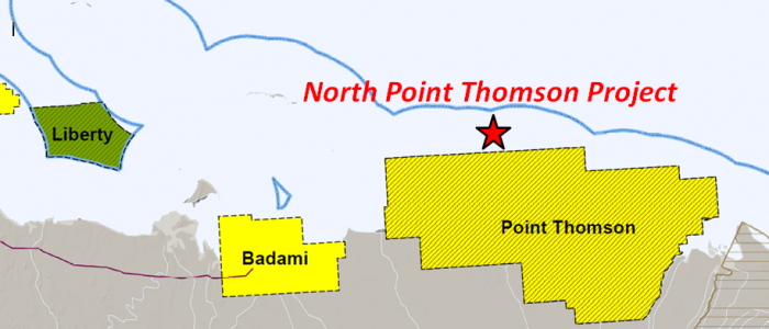
North Point Thomson
North Point Thomson Project
North Pt. Thomson
Offshore, North Slope
- Key Features
- Project lies adjacent to the north border of Point Thomson Unit (295 MMBO, 8 TCFG), 8 miles N.E. of the Badami Unit (60+ MMBO), 8 miles south of the Taktuk Unit (Hammerhead Discovery; (200 MMBO).
- Alaska St. #F-1 Well: tested 284 BOPD (35 API) & 4 MMCFGPD in L. Cretaceous Thomson sand; 152 BOPD (35 API) & 3 MMCFGPD in Pre-Mississippian.
- Alaska St. #A-1 Well: discovery well for Flaxman Island Oil Pool (Tertiary Canning Fm.); tested 4,220 BWPD in Pre-Mississippian.
- Red Dog #1 Well: 1,275’ of oil & gas shows in Tertiary Middle Brookian sands.
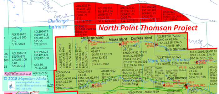
- Leases
Geologic Summary by: D. T. Gross (2/2/2018)
The North Point Thomson Project is located just north of the crest of the Barrow Arch in State of Alaska Waters with depths between 6’ and 20’.The project area is comprised of 5 leases and 1 tract totaling approximately 13,067 acres. Tract ADL 393577 lies along the northern border of the Point Thomson Unit (295 MMBO; 8 TCFG), about ¼ mile north of Challenge Island and the Challenge Is. #1 well. The project acreage is 8 miles northeast of the Badami Unit (60+ MMBO), 9 miles southwest of the Hammerhead-Sivulliq discovery (100-200+ MMBO), 17 miles west-southwest of the Kuvlum discovery (160-300 MMBO), and 14 miles northwest of the Stinson discovery (150+ MMBO).
The Point Thomson Field was “discovered” in 1975 when Exxon’s Alaska State #A-1 well had its 120 feet of Tertiary Flaxman Island turbidites certified as being Capable of Production in Paying Quantities (CPPQ) by the State of Alaska. Based upon the results of the #A-1 well and those of the previously drilled West Staines State #1 (1970) and West Staines State #2 (1971), Exxon received approval to form the Point Thomson Unit in 1977. Later that same year, Exxon encountered hydrocarbons in the L. Cretaceous Thomson sand in its PTU #1 well and this same interval from 12,780’ to 13,128’ MD(TVD) officially became the discovery for the sand. Delineation drilling continued over the years and in 2009 ExxonMobil drilled two more Point Thomson wells, the PTU-15 and PTU-16, as part of a $1.3 billion development project for the field. From 2012 to 2016, ExxonMobil constructed the Point Thomson production facilities which are designed to reinject produced gas back into the reservoir after first separating out the condensate. The liquids are then transported through the Point Thomson Export Pipeline (PTEP) for delivery to the Trans-Alaska Pipeline System (TAPS). Production began April 2, 2016 from the PTU-15 well and the Point Thomson Field has produced 2 MMBO and 38 BCFG to date. The pipeline connection to the Badami Unit has a 70,000 barrel per day capacity and the maximum liquid production potential of Point Thomson is expected to be only 10,000 barrels per day of gas condensate, leaving an excess capacity in the pipeline of 60,000 barrels per day. At a future date, additional production may come from the Sourdough pool, a Lower Tertiary turbidite oil discovery that was made by Chevron and BP in the southeastern corner of the Point Thomson Unit. Their 1997 announcement placed its reserves at 100 MMBO and it has been suggested that this reservoir may extend eastward under the ANWR Area 1002.
The Badami Field initially began production in August of 1998 but suspended production from February to May 1999, again from 2003 until 2005, and a third time starting in September 2007. New partners joining in 2008 and eventually brought the field back into sustained production. The Badami Field was discovered in 1990 by Conoco when their Badami #1 well drilled to 13,595’ MD (12,911’ TVD) and had a drillstem test of over 4,000 BOPD from Brookian turbidite sands (Tertiary). These pay sands were encountered between 9,500’ and 11,500’ MD and were described as being very fine-to-fine grained and moderately sorted with porosities of 15-21%, permeabilities of 1-400 md, and oil gravity of 21-30 degrees API. Original recoverable reserves in these turbidites were placed at 120 MMBO, but were reduced to 60 MMBO after subsequent drilling and production showed that the reservoir sands are complex, consisting of 61 identified fans laid down during seven depositional events. The field was shut-in in 2007 when production dropped to 1,300 BOPD from six straighthole wells. In 2008, Savant (90%) and ASRC (10%) formed a deal with BP in which Savant would drill one new development well (#B1-18A horizontal sidetrack) and one exploration well (Red Wolf #B1-38). The exploration well found oil in its primary objective (Mississippian Kekiktuk Formation) and in a shallower secondary objective (Tertiary Killian sands). Despite a reserve estimate for the Kekiktuk accumulation of 45 MMBO, the Killian horizon was selected to be part of the re-start production which included the new #B1-18A redevelopment well and four previous producers. Savant projected that the combined production from all six wells would eventually be more than 4,000 BOPD, however production has averaged plus or minus 1,000 BOPD since that time. In 2012, Savant targeted the Kekiktuk by drilling the Red Wolf No. 2 well (2 miles northwest of the #B1-38), but the horizon was wet. Recently, plans were announced to drill the Starfish Prospect in 2018, targeting Badami and Killian sands (Canning Formation) within the Badami Sands participating area.
Southwest of the North Point Thomson Project, a unit was proposed in the area between the Badami and Point Thomson units. Named the Telemark Unit, Brooks Range Petroleum Company (BRPC) was seeking to form a 9 lease, 16,235 acre unit. They hoped to delineate and develop the Tertiary “Flaxman Sands” encountered in the E. Mikkelsen Bay State #1 well (1971). Humble Oil (Exxon) drilled the well onshore as a straight-hole to 15,205’ in a location just 1 mile east of the future Badami Unit. The State #1 well had a successful test of Canning Formation turbidites that flowed 24 degree API oil at a rate of 180 BOPD. In 1999 in the northeast portion of the proposed unit, BP Exploration (Alaska) drilled the Red Dog #1 as a directional well (19,400’ MD; 12,379’ TVD) from an icepad on the Beaufort Sea shoreline. The well reached total depth in the Cretaceous Hue Shale with a bottomhole location 2½ miles to the north-northeast of its surface location and less than 6 miles southwest of the present North Thomson Project acreage. Though the primary target zone (17,520-910’ MD) had low porosity due to the predominance of siltstone and clays, the Middle Brookian Sands (Canning Formation) had good oil and gas shows in the interval from 16,845’ to 18,885’MD (10,190’ to 11,888’ TVD). The reservoir quality of these sands was reported to be poor to fair, however the medium-bedded to thin-bedded sandstones displayed porosities of 14-18% with light to heavy oil staining, faint yellow cut, and faint yellow fluorescence. The uppermost sands had 16 degree API oil and most sands had gas shows on the mudlog. The Red Dog #1 was suspended and had its suspension extended until 12/31/2011, but BPX abandoned the well on 5/2/2012. Efforts to form the Telemark Unit were abandoned in exchange for an expansion of the Badami Unit to include the East Mikkelsen prospect.
The North Point Thomson Project sits in the middle of several Tertiary shelf-slope oil accumulations that progress from older to younger as one moves from the southwest to the northeast. The band of oldest accumulations is anchored on its west end by the turbidites of the above discussed Badami and Telemark unit areas and on the east by the discoveries at Yukon Gold (120 MMBO) and Sourdough (100MMBO). The project acreage lies within the next band, younger and to the northeast, which is represented towards its east end by the U. Paleocene Flaxman Sands (Pt. Thomson Unit) and by the Base Eocene Sand (150 MMBO assigned) in the Stinson #1 discovery well. The youngest band was established by Unocal in 1985-86 when they drilled two wells in OCS Block 849, 9 miles northeast of the project acreage. With Shell as a partner, Unocal announced the Hammerhead (Sivulliq) prospect reserves to be between 100 and 200 MMBO in Brookian-aged sands. ARCO extended the Hammerhead play concept in 1992 by drilling three wells along trend to the east in OCS Blocks 865 and 866. The Kuvlum discovery was established when its #1 well flowed 3,400 barrels per day of 34 degree API oil from highly-faulted Oligocene sands. With information from the subsequent #2 and #3 wells, ARCO placed the recoverable Kuvlum reserves at 160 – 300 MMBO. In 1993, ARCO split the distance between their 1990 Stinson #1 Eocene discovery and their Kuvlum Oligocene discovery by drilling the Wild Weasel #1 midway between the two. The well reached total depth in the Oligocene at 9,324’ MD(TVD) but unfortunately encountered no commercial hydrocarbons.
The Hammerhead and Kuvlum leases were relinquished in 1999 when neither Unocal nor ARCO felt that their reserves were sizeable enough to warrant development as stand-alone projects due to the remote location and harsh environment of the discoveries. However, in 2005 Shell acquired the leases encompassing the Hammerhead discovery and had their bids for the Kuvlum leases rejected as being too low ($80,650 per tract). Shell did acquire the five leases on the north and east sides of the tracts that contained the Kuvlum discovery wells, as well as 12 leases even further to the east which were located in a group 10 miles northwest of Kaktovik Village. In 2007 Shell added to their acreage position by winning 27 leases immediately north of both their Hammerhead and Kuvlum lease positions. In the same sale, Total acquired 32 leases adjacent and to the west of this new Shell acreage. Shell renamed Hammerhead as Sivulliq and proposed two new well locations in the OCS block north of the original discovery well, Sivulliq G and Sivulliq N. Six miles further to the northeast, Shell has proposed two more wells, Torpedo H and Torpedo J. In 2016, Shell transferred its leases to AEX and in 2017 the BSEE approved the unitization of 20 leases into the Taktuk Unit. The unit includes the Sivulliq and Torpedo areas and will be operated by ASRC Energy Services.
As one would expect, other targets deeper than the Tertiary have very high potential in the North Point Thomson Project. They are primarily the L. Cretaceous Thomson sand of the Point Thomson Unit and the Pre-Mississippian strata of the 1990 ARCO Stinson oil discovery located just to the east. After reaching a total depth of 16,156’ MD(TVD), the Stinson #1 well’s fractured Franklinian “basement” of sandstone and carbonate strata (Devonian to Precambrian?) was tested in the open hole from 14,863’ to 15,194’ MD(TVD). DST #1 flowed 37 to 51 degree API oil at a rate of 430 BOPD, with 7-18 MMCFGPD and 520 BWPD. It was predicted that flow rates would have reached 700 to 800 BOPD under clean-hole conditions. To the west within the Point Thomson Unit and 7 miles southeast of the project acreage, the Alaska State #A-1 well (14,206’ MD(TVD)) tested a “basement” strata at flow rates of 4,220 BWPD in the openhole (DST #1; 12,997-13,182’ MD). These (ortho)quartzites, dolomites, and shales had been conventionally cored and they displayed oil and water bleeding from fractures in the (ortho)quartzite (Core#10; 12,946-51’ MD) and oil staining in the dolomite (Core#11; 13,019-030’ MD). Eight miles to the west-northwest and 2 miles south of the project acreage, the Alaska State #F-1 well (14,316’ MD; 13,173” TVD) tested the basement strata in the openhole at a rate of 152 BOPD (35 API) with 3.0 MMCFGPD (DST #1; 13,940-14,316’ MD). A second DST of the “basement” taken through a 7” liner and including 36 feet of Thomson Sand perforations also flowed 35 degree API oil, but at the greater rate of 284 BOPD and 4.2 MMCFPD (DST #2; perfs: 13,794-830’ MD; 13,846-86’MD; 13,874-84’MD). Three miles further west and less than 2 miles south of the project area lies the Alaska Island #1 well (15,222’ MD; 13,093’ TVD). Its DST #1was taken through a 5” liner (perfs: 14,997-15,022’ MD) from the basal 3 feet of a 6-foot thick Thomson Sand through the upper 22 feet of the “basement”. Though no average rate was reported, the test flowed between 2 to 3 MMCFGPD with approximately 50 barrels of condensate per day. Further testing attempts ceased when a perforation gun became stuck and subsequently gas began “flowing out of hole”. The well was killed by reverse circulation through perforations shot at 12,460’ MD, however the well again began flowing and the “pit level was increasing with gas cut mud returns” so the well was killed again using 16.8# mud. No more testing was attempted and the Alaska Island #1 was plugged using cement in the lower hole. Diesel was left in the tubing because as late as 1987 the operator reported that “This well may be considered for future exploration drilling/testing operations dependent upon results of the Point Thomson Unit common data base(sic) evaluation”. This did not come to pass and the well was abandoned on 8/28/1988. An additional three miles west and only a quarter mile south of the North Thomson Project acreage, another well experienced even worse hole problems than the Alaska Island #1 well would have the following year. The Challenge Island #1 well (13,587’ MD; 13,094’ TVD) was able to drill, core, and log down into the Tertiary to a depth of 10,378’ MD (9,878’ TVD). The well drilled and cored deeper, encountering the Thomson Sand at 13,440’ MD and the LCU/Basement at 13,490’ MD, but upon reaching total depth the well lost circulation and then began to flow. The driller was “unable to circ. out of hole without losing returns” and was “unable to pump down annulus”. As a result, the objective section was neither logged nor tested and the hole was plugged and abandoned. However, Core #4 (13,482-516’ MD) had successfully cut and recovered 34 feet of strata, the top being the basal 8 feet of the Thomson Sand which was composed of dolomite and conglomerate with fractures and vugs that bled brown oil (dull yellow fluor.). The underlying 26 feet of “basement” was described as argillite and siltstone interbedded and grading to a dolomitic siltstone. Throughout the dolomitic siltstone, fractures and vugs bled oil and water (dull gold fluor.). Thus the North Thomson Project area sits along an east-west line of exploratory wells that encountered carbonate-rich, Pre-Mississippian “basement” lithologies. The line starts eight miles to the east with the Stinson #1, then the Alaska State #A-1, the Alaska State #F-1, the Alaska Island #1, and continues through the Challenge Island #1 on the western end of the North Point Thomson Project before extending westward towards the Liberty Unit area.
The potential for Thomson sand hydrocarbon accumulations in the North Point Thomson Project was perhaps best laid out in the report: “2002 Point Thomson Unit, Application for the Second Expansion and Third Contraction of the Unit Area”. In the Findings and Decision of the Director, Division of Oil and Gas, the geologic reasoning for approving Expansion Areas #1, #2, and #6 pertain directly to the project acreage. For Expansion Area #1, which includes the southwestern portion of the project area, the Director found that the main Thomson Sand Reservoir probably continues northwesterly beneath this area based upon the 64 feet of sand in the Challenge Island #1 well, the 6 feet of sand in the Alaska Island #1 well, and supporting seismic data. It should be noted that the former well, though neither logged nor tested, did have two conventional cores cut in the Thomson Sand which showed it to be a sandstone/conglomerate with good visible porosity, oil shows throughout (bright yellow fluor.; some oil bleeding from fractures), and gas bubbling from the core (Core #2: 13,438-64’ MD; Core #3: 13,464-87’ MD). Immediately to the east in Expansion Areas #6 and #2, the Director determined that dividing them into two geologically distinct areas was appropriate. “Expansion Area #6 encompasses the northern flank of a ridge-like structural feature constraining the Thomson Sand accumulation in the PTU area. While Thomson Sand thickness is uncertain in Expansion Area #6, seismic and well data indicate the probability that the Thomson Sand Reservoir is present on the north flank of the feature and will contribute to production when drilled and developed.” He went on to note that the drilling results from two wells, Alaska Island #1 and Alaska State F-1, “contribute to DNR’s evaluation of Expansion Area #6.” The former well had a thin 6-foot thick sand that tested gas and condensate and the latter well “encountered approximately 47 feet of Thomson Sand that flowed gas and gas condensate, which is what we would likely expect to encounter drilling in Expansion Area #6.” What the Director did not account for in this finding was that Expansion Area #6 and most of the North Point Thomson Project area may have a much greater potential for oil production due to its position on the “northern flank of a ridge-like structural feature”. According to the USGS (Open File Report 98-34), this northern flank would have been oil-charged from the north as part of the Canning-Sagavanirktok Petroleum System, as were the Hammerhead(Sivulliq) and Kuvlum oil discoveries in the OCS waters. The gas-prone accumulations on the south side of this “ridge” in the Point Thomson Unit were charged from the south as part of the Ellesmerian and Hue Petroleum Systems.