South Liberty
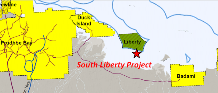
South Liberty Project
South Liberty
Offshore, North Slope
- Key Features
- Project lies along south border of the Liberty Unit (80-150 MMBO), 5 miles southeast of the Duck Island Unit (585 MMBO), and 6 ½ miles west of the Badami Unit (60+ MMBO).
-
- West Mikkelsen State #1 Well: tested 26 degree API oil at a rate of 302 BOPD from the Tertiary Canning Formation.
- West Mikkelsen Unit #4: tested 21 API oil at a rate of 35 BOPD in the uppermost Mississippian Kektiktuk above other tests with flow rates up to 1,328 BOWPD .
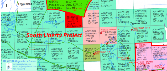
- Leases
- ADL 392136 (12/31/2022)
Geologic Summary by: D. T. Gross (2/1/2018)
The East Liberty Project is comprised of one lease totaling approximately 2,029 acres located upon the crest of the Barrow Arch. The lease is in State of Alaska Waters (Foggy Island Bay) with depths of less than 6’. The project area is immediately adjacent to the southern boundary of the Liberty Unit, is 6 ½ miles west-northwest of the Badami Unit, and is 5 miles east-southeast of the Duck Island Unit. The Endicott Field (Duck Island Unit) has produced 486 million barrels of oil and 3.4 trillion cubic feet of gas primarily from the Mississippian Kekiktik Conglomerate with a contribution from the Lower Triassic Sadlerochit-Ivishak. The Liberty Unit is presently planning to utilize an artificial gravel island and extended reach drilling in order to produce the 80-150 million barrels of oil assigned to its Mississippian Kekiktuk Formation. The Badami Unit is a 60+ MMBO field and has yielded 8.0 MMBO and 33 BCFG to date primarily from Tertiary turbidite sands.
The Liberty Unit is expected to commence construction of its 9-acre artificial island (5.5 miles offshore; 19’ water depth) in 2019 with first oil being produced in 2022. The reservoir and trap is similar to that of Endicott Field (Duck Island Unit), one mile to the northwest along structural trend. At Liberty, the oil in the Mississippian Kekiktuk Zone 2 sandstone is confined in a structural-stratigraphic trap atop the Barrow Arch between the Tigvariak Fault to the southwest and an erosional truncation by the overlying Lower Cretaceous Unconformity (LCU) to the northeast. The Liberty #1, the field’s discovery well drilled in May of 1997, encountered the top of the Zone 2 sandstone at -10,707’ SS and a tar mat at -10,932’ SS. The tar mat demarks the base of the reservoir and is similar to mats found in the Endicott and Prudhoe Bay oilfields.
The Badami Field initially began production in August of 1998 but suspended production from February to May 1999, again from 2003 until 2005, and a third time starting in September 2007. New partners joining in 2008 eventually brought the field back into sustained production. The Badami Field was discovered in 1990 by Conoco when their Badami #1 well drilled to 13,595’ MD (12,911’ TVD) and had a drillstem test of over 4,000 BOPD from Brookian turbidite sands (Tertiary). These pay sands were encountered between 9,500’ and 11,500’ MD and were described as being very fine-to-fine grained and moderately sorted with porosities of 15-21%, permeabilities of 1-400 md, and oil gravity of 21-30 degrees API. Original recoverable reserves in these turbidites were placed at 120 MMBO, but were reduced to 60 MMBO after subsequent drilling and production showed that the reservoir sands are complex, consisting of 61 identified fans laid down during seven depositional events. The field was shut-in in 2007 when production dropped to 1,300 BOPD from six straighthole wells. In 2008, Savant (90%) and ASRC (10%) formed a deal with BP in which Savant would drill one new development well (#B1-18A horizontal sidetrack) and one exploration well (Red Wolf #B1-38). The exploration well found oil in its primary objective (Kekiktuk Formation) and in a shallower secondary objective (Late Cretaceous(?)/Tertiary Killian sands). Despite a reserve estimate for the Kekiktuk accumulation in the #B1-38 well of 45 MMBO, the Killian horizon was selected to be part of the re-start production which included the new #B1-18A redevelopment well and four previous producers. Savant projected that the combined production from all six wells would eventually be more than 4,000 BOPD, however production has averaged plus or minus 1,000 BOPD since that time. In 2012, Savant targeted the Kekiktuk by drilling the Red Wolf No. 2 well (2 miles northwest of the #B1-38), but the horizon was wet. Recently, plans were announced to drill the Starfish Prospect in 2018, targeting Badami and Killian sands (Canning Formation) within the Badami Sands participating area.
Aside from the Liberty Unit wells, there are four key wells adjacent to the South Liberty Project. Three of these wells were drilled within the West Mikkelsen Unit that was formed by Shell Oil in August of 1978 and dissolved in January of 1985. The West Mikkelsen State #1well lies 3 miles south-southeast of the East Liberty Project and 5 miles west of the present Badami Unit boundary. The well was drilled by ConocoPhilips Alaska in November of 1978 to a depth of 15,620’ MD(TVD) in order to test the strata down through the Mississippian Kekiktuk Formation. Nine conventional cores were taken: two in the L. Cretaceous Kemik sandstone (11,236’-309’ MD); four in the Carboniferous Lisburne (11,309’-733’ MD); and three in the Kekiktuk (13,700’-748’ and 14,048’-079’ MD). Tests yielded no fluids from the Kekiktuk and only a small amount of oil and gas from the Lisburne, but the Tertiary Canning Formation flowed 26 degree API oil at a rate of 302 BOPD. Based on this test, the lease has been Held-By-Well (HBW) to the present day despite the well having been abandoned on 2/10/2010.
Six miles east-southeast of the project’s acreage, ARCO drilled the West Mikkelsen Unit #2 in 1979, penetrating basement and reaching a depth of 11,930’ MD (11,920’ TVD). Three conventional cores (10,376’-555’ MD) were cut in the Tertiary Canning Formation which showed it to be composed of sandstones and siltstones which contained oil. A fourth conventional core was cut in basement rock (11,664’-714’ MD) and revealed it to be quartzite and argillite. The well was plugged and abandoned due to the lack of economic hydrocarbon accumulations. It should be noted that two miles further to the south-southeast, Conoco drilled the Badami #2 well in 1992 and tested the Canning Formation at a rate of 373 BOPD (10,494’-082’ MD(TVD)).
To the southeast of the South Liberty Project, Shell Oil drilled the West Mikkelsen Unit #3 well in 1982. The well was drilled directionally 1.4 miles to the northwest from its surface location on the made-made Goose Island and had a bottomhole location only 2 miles from the project area. The well was plugged and abandoned at a depth of 14,430’ MD (11,242’ TVD) after numerous drilling problems and failing to recover a 4.5” drillpipe stuck in a sidetrack into the L. Cretaceous Pebble Shale unit. The Mississippian Kekiktuk Formation, the apparent target of the well, was not reached. The next year, Shell was able to reach the Kekiktuk by drilling a straight-hole well directly above the #3 target location to a depth of 13,060’ MD(TVD). The West Mikkelsen Unit #4 cut 12 conventional cores in the Kekiktuk (11,298’-363’ MD) which showed it to have been deposited upon the basement in a shoreline environment, indicated by the presence of coals intermingled with its sandstones, siltstones, and shales. The sandstones had porosities up to 25% and production tests taken through casing had flow rates up to 1,328 BOWPD (Test #1, 11,544’-582’ MD). Test #4 in the uppermost Kekiktuk flowed 21 API oil at a rate of 35 BOPD (11,317’-348’ MD). The well was abandoned on 5/21/1983.
As shown by a Canning Formation structure map provided to the AOGCC, the turbidite hydrocarbon accumulations within the Badami Unit are stratigraphically trapped within Tertiary submarine fan sands that dip to the northeast. As a result, on the South Liberty Project leasehold it is likely that similar turbidite sands are present and it would be among the “first in line” to receive any oil migrating updip out of the Dinken Graben that lies to the north. Other deeper targets also appear to be viable for the project. These include the Killian Sands (Tertiary Canning Fm.) of the Badami Unit and equivalents of the Cretaceous Thomson Sands of the Point Thomson Unit. The Mississippian Kekiktuk Formation is productive in the Liberty Unit and has production potential in the Badami Unit. Even an upper basement target is possible, much like the ARCO Stinson #1 oil discovery made in 1990 just to the east of the Point Thomson Unit. This fractured Franklinian basement of sandstone and carbonate strata (Devonian to Precambrian) was tested in the open hole from 14,863’ to 15,194’ MD(TVD). DST #1 flowed 37 to 51 degree API oil at a rate of 430 BOPD, with 7.1-18.0 MMCFGPD and 520 BWPD. It was predicted that flow rates would have reached 700 to 800 BOPD under clean-hole conditions. To the west and within the Point Thomson Unit, the Alaska State #F-1 well tested the basement strata at 152 BOPD (35 API) with 3.0 MMCFGPD and the Alaska State #A-1 well had a test with flow rates of 4,220 BWPD.
Additionally, though they have yet to announce exploration plans, it is important to note that ConocoPhillips Alaska bid a total of $1,357,902 in the North Slope 2014W Lease Sale in order to acquire a three-lease position contiguous to the east and southeast of the South Liberty Project.