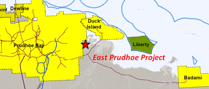
East Prudhoe
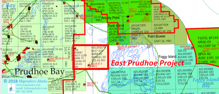
East Prudhoe Project
East Prudhoe
Onshore, North Slope
- Key Features
- Project lies along east border of the Prudhoe Bay Unit (15.2 BBO), 1 ½ miles southwest of the Duck Island Unit (585 MMBO), and 8 miles west of the Liberty Unit (80-150 MMBO).
-
- AMOCO Foggy Island Bay State #1 Well: tested 123 barrels of oil and 242 barrels of water from Mississippian Lisburne.
- Sag Delta #11 Well: tested produced 38 BO and 222 BW at rates up to 480 BFPD from Mississippian Lisburne.
- ARCO Delta State #2 Well: had multiple oil shows and tests from Mississippian Lisburne (27-30 API).
Geologic Summary by: D. T. Gross (1/31/2018)
The East Prudhoe Project is located along the eastern border of the Prudhoe Bay Unit and is comprised of two tracts totaling approximately 3,840 acres, which may be adjusted once the leases are finalized. The project area is 1 ½ miles southwest of the Duck Island Unit and is 8 miles west of the Liberty Unit. The Prudhoe Bay Field’s cumulative production is 12.7 billion barrels of oil and 85.6 trillion cubic feet of gas from strata ranging in age from Carboniferous to Cretaceous. The Endicott Field (Duck Island Unit) has produced 486 million barrels of oil and 3.4 trillion cubic feet of gas primarily from the Mississippian Kekiktik Conglomerate with a contribution from the Lower Triassic Sadlerochit-Ivishak. The Liberty Unit is presently planning to utilize an artificial gravel island and extended reach drilling in order to produce the 80-150 million barrels of oil assigned to its Mississippian Kekiktuk Formation. Construction is expected to begin in 2019 with first oil produced in 2022.
Due to the East Prudhoe Project’s location so near to established production, numerous exploration wells have been drilled upon and adjacent to its acreage. These wells point to bypassed reservoirs that could be economic today given the recent advances in drilling and production technology. Going from north to south, there are four wells of interest.
One mile to the east of the East Prudhoe Project area, the AMOCO Foggy Island Bay State #1 was drilled in April of 1975 as a straight hole to a depth of 10,746’ MD(TVD). The well was suspended until it was plugged and abandoned eight years later in September of 1983. The well encountered its target Mississippian Lisburne limestone at 9,666’ and two conventional cores were cut through it (Core #1, 9,774-9,815’; Core #2, 9,815’-9835’). These cores showed that the Lisburne contained vertical fractures and zones with porosities up to 3.6%, permeabilities up to 20 md, and water saturations as low as 48%. Five drillstem tests were run in the Lisburne, with DST#4 having a total recovery of 123 barrels of oil and 242 barrels of water from strata between 10,092’ and 10,092’.
Four miles west of the Foggy Island Bay State well on the boundary between the project area and the Prudhoe Bay Unit, the Sag Delta #11 well was drilled by SOHIO in 1985 to a depth of 10,400’ MD (10,350’ TVD). The target for this well was also the Lisburne which was encountered at 9228’MD. Thirteen conventional cores were taken from 9201’MD to 10,119’MD and they displayed oil staining, fluorescence, and streaming cuts throughout, as well as zones of oil bleeding from pores and fractures. It was noted as depth increased, re-crystallization of the limestone resulted in increased porosity. SOHIO also ran 3 open-hole tests and 5 cased-hole tests in the well. DST#3 tested the interval 9,999’ – 10,119’MD and produced 38 BO and 222 BW at rates up to 480 BFPD. The well was abandoned in April, 1985.
Two miles to the southeast of the Sag Delta #11 well and within the project area, the ARCO Delta State #2 well was drilled to a depth of 11,026’ MD(TVD) in May of 1975. The well was suspended until it was abandoned 21 years later in March of 1996. The Lisburne was tested in a deep zone at 10,326’-10,695’ that produced a total of 750 barrels of 30 API oil and water, with a water cut starting at 35% (rising to 93%) and at rates of 1700 BFPD (falling to 576 BFPD). A shallower zone at 9,956’-10,096’ recovered a total of 103 barrels of oil at a ratio of 55% oil and 45% water at a rate of 360 BFPD along with 71 MCFG. Near the top of the Lisburne, a test from 9,423’ to 9,770’ recovered 427 barrels of fluid at a ratio of 45% oil and 55% water, however the well died after 19.5 hours. Directly above the Top Lisburne, the strata yielded 394’ of oil in one test and a DST from 9268’ to 9519’ returned 4 barrels of 27 API oil that was heavily gas cut. Two conventional cores were taken between 9,415’ and 9,453’ which showed the Lisburne to be a vuggy limestone with oil saturations up to 52%, porosity up to 15.4%, and permeability up to 9.4 md.
Two miles south of the Delta State #2, the ARCO Delta State #1 well had been drilled six years earlier in February of 1969 to a depth of 10,001’ MD(TVD). The well was suspended until it was abandoned 26 years later in March of 1995. Once again, the Lisburne Limestone was the objective and 5 conventional cores were taken between 8,938’ and 9,932’ in order to analyze its lithology. The top Lisburne was identified at 9,350’ and it had oil shows in Core #3 and Core #4, (9,366’-9,386’ and 9,751’-9,771’, respectively). Core #4 also had a two foot interval of fractures (9,589’-9,591’) into which circulation was lost during drilling. Interestingly, bleeding gas was noted in the core taken in the shale section above the Top Lisburne (Core #2; 9,308’- 9,328’). Within the Lisburne, 6 wireline formation tests were run that yielded gas, water, and a trace of oil.
If the oil and gas accumulations of the East Prudhoe Project are shown to be economic and contiguous with those of the Prudhoe Bay Unit, then unit expansion would be in order. In July of 2009, the PBU was expanded to include three new areas on its northern border (Area # 1 & #2 in the Point McIntyre PA and Area #3 in the Raven PA). If the reserves are separate from the Prudhoe Bay Field, then a new unit should be formed over the East Prudhoe Project reserves. Formation of a unit will probably require the re-evaluation of the existing well information using computer modeling software in order to identify all bypassed hydrocarbon accumulations, along with the examination of all newly available seismic data. This would follow the model of the recently approved Guitar Unit on the southern border of the Prudhoe Bay Unit. Alliance Exploration presented 3D seismic data that was shot over the expired Storms Unit combined with data from the Hemi Springs State #1 well to make their case for unitization. The new paradigm on the North Slope is that hydrocarbon reserves that were recognized but deemed uneconomic decades ago may be very profitable today given the advances in modern drilling and production technology, changing market demands, and the proposed construction of a North Slope Gas Pipeline.